

The Los Angeles-area wildfires can easily be seen from space, both by satellites and astronauts on the space station.
California’s year of destructive wildfires continues with a series of new blazes burning around the Los Angeles area this week. LA residents have been sharing eye-opening photos of the fires shooting flames near major roadways. The view from space offers a different, but just as devastating, perspective on the burn areas.
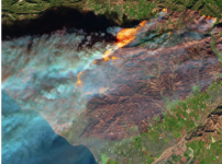
NASA shared a false-color image on Thursday from the European Space Agency’s Sentinel-2 satellite. It highlights a brown burn scar north of the city of Ventura. The flames stand out starkly as smoke billows toward the Pacific Ocean. Untouched areas of vegetation appear in bright shades of green.

This view from the ESA’s Sentinel-2 satellite shows wildfires near Ventura, California on Dec. 5.
The fires are destroying buildings and eating up ground near cultural resources, including The Getty Center. Strong, dry Santa Ana winds are fanning the fires and making it very difficult for firefighters to curb the blazes. Nearly 200,000 residents have been evacuated as the winds and fires rage on.
NASA astronaut Randy Bresnik viewed the fires from his vantage point on board the International Space Station and shared the apocalyptic images on Twitter:
I was asked this evening if we can see the SoCal fires from space. Yes Faith, unfortunately we can. May the Santa Ana’s die down soon.
